Round we go – Circular walks on the Wales Coast Path
Stretching for 870 miles (1,400km) around the country’s entire shoreline, the Wales Coast Path is probably best-known for its linear, point-to-point seaside routes. But that’s only part of the story. By linking up with local footpaths and rights of way, you can turn a one-way walk into a circular route that takes in both coast and countryside. You can find a full list and a map on our circular walks page, but here are a few to get you started.
Aberdyfi
At a manageable 4.6 miles/7km, this loop begins and ends in Aberdyfi, the pretty coastal town sitting at the mouth of the Dyfi Estuary. Once a busy harbour and shipyard, it’s now a classy seaside destination popular with beach lovers (it’s huge) and watersports enthusiasts (the windsurfing is particularly good here). There’s a network of narrow streets to explore, plus attractions like the Dovey Yacht Club, which stages regular events on the water, and Aberdovey Golf Club, a classic links course established in 1892 amid the wind-sculpted dunes that line the shore.
While you’re close to the sea, keep an ear out for the sound of distant bells. According to legend, they belong to the lost kingdom of Cantre’r Gwaelod which sank beneath the waves in the early medieval period. As a nod to this legend, there’s a sea bell suspended beneath the quayside jetty.
The walk takes you along the seafront before climbing up past a rocky outcrop believed to be the former site of a medieval castle (the gazebo that now occupies this elevated spot commands fantastic views along the coast). Turning inland, you’ll travel through a patchwork of lush farmland, before rejoining the Wales Coast Path and returning to your start point in Aberdyfi.
Download the Aberdyfi circular walk leaflet for more information.
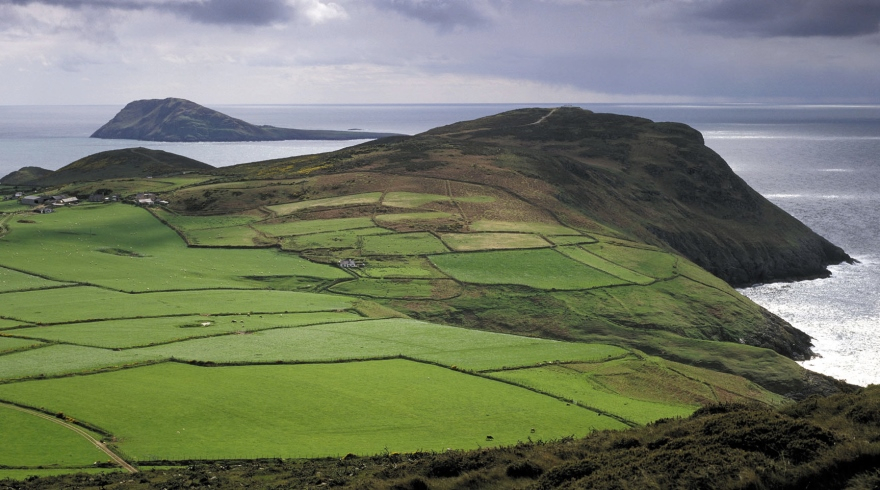
Botwnnog
This walk takes in coast and country on the Llŷn Peninsula, an Area of Outstanding Natural Beauty. That’s not the only accolade this special place has received – it has also been designated for nature conservation and as an historic landscape of exceptional interest. Go here for the full picture.
Beginning and ending in the little village of Botwnnog near Abersoch on the tip of Llŷn, this walk stretches through 9.3 miles/15km of countryside and spectacular coast. Though the terrain is largely level, you’ll find plenty of highlights along the way. The outward leg leads you along quiet lanes and pathways through a landscape dotted with historic churches.
Along the way you’ll pass Eglwys Llandygwnning, with its unique round tower and Eglwys Llangian, where you’ll find an inscribed stone dating back to the 5th or 6th century. There’s also the beautiful Eglwys Llanengan, home to ancient church bells and an oak screen said to have originally been part of the now demolished abbey on the holy island of Bardsey.
There’s even more history along the route at Pen-y-gaer. This Celtic hillfort requires a brief detour off the main path, but the views from the top are well worth the effort. You’ll also be able to spot the ventilation chimney of the former Tanrallt lead mine on the outskirts of Llanengan.

On your return leg, you’ll join the Wales Coast Path and trace the dramatic sweep of Porth Neigwl (Hell’s Mouth in English). The site of dozens of shipwrecks over the centuries, these days its crashing waves are a magnet for experienced surfers.
Download the Botwnnog circular walk leaflet for more information.
Llangwnnadl
Looping around the little village of Llangwnnadl on the Llŷn Peninsula’s northern side, this walk packs a lot into its compact 4-mile/6.4km length. Starting from the car park about half-a-mile north of the village, you’ll quickly join the Wales Coast Path at Penllech Beach before reaching Porth Colmon, a small harbour tucked into the rocky coast. It’s a quiet spot today, but was once a bustling port where lime, coal and bone meal were brought ashore (alongside smugglers’ illicit cargoes).

Further along the coast is Porth Tŷ Mawr, site of a famous shipwreck in 1901. Not long into its journey from Liverpool to New Zealand, a ship called the Stuart got into difficulties and ran aground. Though the crew all escaped safely, the ship was broken up by the waves, releasing a cargo that contained everything from crockery and pianos to large amounts of whisky. The locals were quick to gather up as much of the bounty as they could – the place is known by the alternative name of Porth Wisgi to this day. At very low tides some of the Stuart’s remains can still be seen.
From the coast, the route passes through fields and farmland before reaching Eglwys Llangwnnadl. Entered via a gate bearing the words Tŷ Duw (God’s House) it is one of a network of churches located along the Pilgrim’s Trail, the holy route that stretched from Basingwerk Abbey in Holywell to the sacred island of Bardsey. The ‘isle of 20,000 saints’, off Llŷn’s western tip.
Download the Llangwnnadl circular walk leaflet for more information. See also the links on Llŷn’s Area of Outstanding Natural Beauty and other designations that highlight the peninsula’s nature conservation and historic landscape of exceptional interest
Be sure to follow The Countryside Code for tips on how to enjoy the outdoors considerately and respectfully.